Posts

Showing posts with the label Belfast

Stop Eating Dog Food – Start Drinking Champagne!
Image
Photo by Walter Nissen (Wnissen). (Own work) [Public domain], via Wikimedia Commons I first encountered the term ‘Dogfooding’ or ‘to eat your own dog food’ last year at the 2016 Tableau conference in Austin, TX. I was attending a session on how Tableau use their own product to visualise their HR data. The presenter uttered the line ‘We firmly believe in eating our own dog food’. The meaning was immediately clear to me – if it’s not good enough for internal usage, it’s hard to make the case that others should invest in the product. Literally: if it’s not good enough for me, it’s not good enough for my dog. Great … I get the idea fully & clearly … Unfortunately, I also have a strong smell-memory of dog food that’s triggered every time I hear the term. I’m not joking! As I’m writing this the air is heavy with the imagined scent of tinned dog food … it’s not pleasant! Once the Tableau presentation ended I was free of the term – while it may have some currency in the US...

Belfast Bike Hire Rentals & Returns

Image
Screenshot of the Tableau Dashboard. Available [ here ] and at the end of this post. [Note: the dashboard is best viewed in Full Screen (F11) Mode] This Visualisation uses two datasources provided by OpenDataNI. The first is the Belfast Bike Hire Rentals and Returns dataset ( https://goo.gl/fjkRj3 ). Along with the numbers or Rentals and Returns, it is broken down by Location, Month, and Year. Each location name is accompanied by a Station Number. This is used as the key to join to the Belfast Bike Hire Stations dataset ( https://goo.gl/CxpjXM ) which, among other things, has contains the Latitude & Longitude (even if it is mistitled 'Longfitude'). There are a number of location naming inconsistencies in the Rentals data, so I've used the names as supplied in the Stations resource instead. The left side of the visualisation is taken up with a map of central Belfast. There is a dot for every Bike Station, sized by the number of Rentals or Returns & colou...

Finding your Public Amenities in Northern Ireland

Image
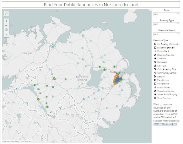
Screenshot of the Tableau Dashboard. Available [ here ] and at the end of this post. I was recently thinking back to last year’s ODI Belfast unConference where someone mentioned one of the smallest (and, by implication, the least useful) datasets available on their website [ here ] – the  list of 22 Bowling Pavilions in Belfast City. The question was ‘what can you possibly do with a list of 22 bowling pavilions?’ I seem to remember the suggestion that they might be useful in the event of a Zombie Apocalypse where they could be put to use as holding centres for the contaminated. I’m not a huge fan of the Zombie genre, but even I know that this approach will not end well. So … what do you do with a list of 22 Bowling Pavilions? This is a question that has been ticking away in the back of my head for a while now (wow … I really don’t have the richest internal life, do I?) … how do you use this kind of data in a useful way? Sure … I can build you a dashboard that shows all of...